UK weather: Bank Holiday washout delays summer scorcher as Atlantic swirls hurl stormy weather around Britain (0.006664067130871443)
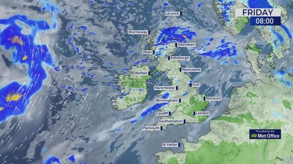
<iframe frameborder="0" height="100%" scrolling="no" src="https://www.gbnews.com/res/scraper/embed/?video_url=https%3A%2F%2Fmm-v2.simplestream.com%2Fiframe%2Fplayer.php%3Fkey%3D3Li3Nt2Qs8Ct3Xq9Fi5Uy0Mb2Bj0Qs%26player%3DGB003%26uvid%3D52901548%26type%3Dvod%26viously_id%3DGZior8IaDT6" width="100%"></iframe><br/><p>Summer could be delayed by a week with five more days of rain to washout the end of spring.</p><p>The Atlantic will continue to hurl stormy weather systems at the UK possibly until after the first week of June.</p><h3></h3><br/><p>Much of this week, including the Bank Holiday and half term, will be chilly, wet, and occasionally windy.</p><p>Met Office meteorologist Honor Criswick said: “Overall, for the Bank-holiday weekend, it is going to be changeable and unsettled at times, but the wettest of the weather will be across the northwest and it will be feeling a bit cooler here, but it will be warm across the east.</p><h3></h3><br/><img alt="Rain is expected across much of the country today" class="rm-shortcode" data-rm-shortcode-id="3444e0c347b714602452a7cf918937a4" data-rm-shortcode-name="rebelmouse-image" id="9af2c" loading="lazy" src="https://www.gbnews.com/media-library/rain-is-expected-across-much-of-the-country-today.jpg?id=60319760&width=980"/><h3></h3><br/><div class="embed-latest"></div><h3></h3><br/><p>“Looking at the pressure trend, and the next two weeks are quite mixed, and this indicates that it is quite changeable with some frontal systems moving in.</p><p>“There is an indication that high pressure will eventually build back through, but there is a chance that might not be until the middle part of June, but it is too early to say.”</p><p>Despite the soggy forecast, farmers and gardeners desperate for rain after a near-record dry spring are in luck.</p><p>And where the clouds part, parts of the country will enjoy periods of blue sky and relatively warm sunshine.</p><h3></h3><br/><img alt="Temperatures will remain around 12C in the UK" class="rm-shortcode" data-rm-shortcode-id="40482990132a9bf0a02a867471119471" data-rm-shortcode-name="rebelmouse-image" id="99aa6" loading="lazy" src="https://www.gbnews.com/media-library/temperatures-will-remain-around-12c-in-the-uk.jpg?id=60319766&width=980"/><h3></h3><br/><div class="embed-dontmiss"></div><h3></h3><br/><p>Jim Dale, meteorologist for British Weather Services, said: “It is not going to be raining everywhere all the time, but the weather is going to stay changeable for the next five to seven days, and this means heavy rain for some.</p><p>“However, this is going to be good news for farmers and gardeners who have had very little to no rain for the last few weeks.</p><p>“Scotland will hold on to the wet weather longest, while things start to turn drier further south.”</p><p>Jason Nicholls, lead international forecaster for AccuWeather, added: “It is going to be wet across much of the UK through midweek, and there will be showers or longer spells of rain.</p><h3></h3><br/><div class="embed-mostread"></div><h3></h3><br/><p>“With these, there will be some brighter periods at times, and these will return to southern areas later in the week.</p><p>“Northern parts of the country will have showers and cloudy skies for longer.”</p><p>Britain’s weather this week will be driven by the jet stream pulling areas of low pressure into Britain.</p><p>A huge ‘blocking high’ pressure pattern which has brought weeks of rainless skies will crack to let in the downpours.</p><h3></h3><br/><h3></h3><br/><p>But looking further ahead, things are looking up with high pressure set to return before the middle of June.</p><p>Dale said: “There is wet weather on the way, but this should start to dry up after about a week, and then we are back to high pressure.</p><p>“This means more dry, warm and sunny weather widely across the UK.”</p><p>Government forecasters agree that high pressure is likely to win the battle before too long into the start of summer.</p><p>Honor Criswick said: “The next two weeks are quite a mix, and it is likely into next week we will still see some frontal systems moving in but at times we will also see some ridges of high pressure, so we will see some rain and some dry interludes.”</p>